
11 Best Trails and Hikes Await Your Adventure in Albania!
Gear up for an adrenaline-pumping journey through the breathtaking landscapes of Albania’s trails and hikes! 🌄🥾 Whether you’re into trails and hikes, mountain biking, climbing, or simply immersing yourself in the great outdoors, all Trails has your adventure checklist covered. We present to you a curated collection of 11 trails and hikes, offering a mosaic of experiences that go beyond your wildest outdoor dreams.
Immerse yourself in the magic of Albania’s nature with our hand-curated trail maps, enriched with insights, reviews, and stunning photos shared by fellow nature enthusiasts. 🗺️📸 From cascading waterfalls to panoramic vistas, our trails promise an immersive experience tailored to every adventurer’s delight.
So, pack your gear, lace up those boots, and embark on a journey that transcends the ordinary. Albania’s best trails and hikes await – are you ready to write your own adventure story? 🌿🚵♂️
Navigating Trails and Hikes
Easy: 🍃
- These trails are beginner-friendly.
- Mostly flat terrain with well-marked paths.
- Suitable for all ages and fitness levels.
- Shorter distances, typically less strenuous.
Moderate: ⛰️
- Ideal for those with some hiking experience.
- Involves varied terrain and occasional elevation changes.
- Moderate endurance required.
- Longer distances and a bit more challenging.
Hard: 🏞️🥾
- Advanced trails for experienced hikers.
- Steep inclines, rugged terrain, and significant elevation changes.
- Requires excellent physical condition and stamina.
- Longer distances with potentially difficult conditions.
Stuck in the car rental dilemma? 🤔 Discover the ultimate guide to renting a car in Albania – your ticket to a smooth, carefree adventure. Click here for easy tips on renting a car. 🗺️🔓
Easy Trails and Hikes in Albania
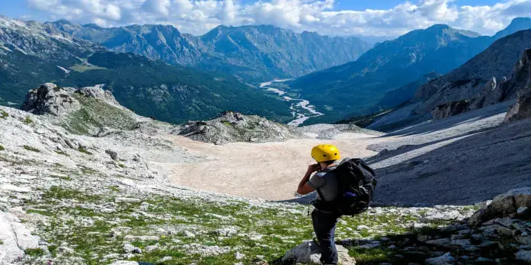
Maja e Jezerces
📍 Tropojë, Kukës, Albania | 🥾 Length: 4.3 km | 🕒 Est. 2h 44m
Maja e Jezerces, also known as the “Queen of the Alps,” stands as a hidden gem in the Dinaric Mountains, near the Albanian-Montenegrin border. As the highest peak in North Albania, it offers both challenge and reward. The ascent involves rocky terrain, so be prepared and consider bringing a helmet for added protection. Depending on the season, crampons and an ice axe may also be necessary.
The journey begins in Fusha e Gjes, Valbona Valley, passing through the village of Rrogam. Keep an eye out for a small sign indicating the left path to the village of Theth (Valbone – Theth) or the right path to Maja e Jezerces. Along the way, you’ll encounter a fixed rope near the summit, boosting your confidence as you ascend.
Remember not to confuse the trail with another nearby peak called Popluka Peak. With proper preparation, reaching the summit of Maja e Jezerces can be an unforgettable highlight of your hiking adventure. 🌿🚶♂️
🗣️Trail Highlights:
- Scenic Beauty: As you ascend, you’ll be treated to amazing views of the surrounding landscape.
- Queen of the Alps: Maja e Jezerces is the highest peak of the Prokletije (Accursed Mountains) and is rightfully called the “Queen of the Alps.”
- Access Routes: There are several ways to climb this mountain, but the most popular route starts from Fusha e Gjes’ in Valbona Valley.
🗺️How to Get There:
To reach the trailhead:
- Starting Point: Begin your journey from Tropojë, a town in the Kukës region of Albania.
- Valbona Valley: Head toward Valbona Valley. This pristine valley is known for its stunning natural beauty and serves as the gateway to the Accursed Mountains.
- Fusha e Gjes: From Valbona Valley, proceed to Fusha e Gjes. This is where your hike to Maja e Jezerces begins.
- Trail Entrance: Look for signs or markers indicating the trail entrance. The path will lead you toward the majestic peak.
Nivicë – Senicë
📍 Gjirokastër, Albania | 🥾 Length: 5.3 km | 🕒 Est. 1h 34m
Nivicë – Senicë is like a well-kept secret—a remote destination that beckons adventure-seekers tired of overcrowded trails. As one of the longest canyons in Europe, it spans 40 kilometers (24.9 miles) in length and 15 kilometers (9.3 miles) in width. Few people know about it, making it an ideal escape for those who crave solitude and breathtaking vistas.
So, pack your hiking gear, follow the trail markers, and immerse yourself in the rugged beauty of Nivicë – Senicë. 🏞️🥾
🗣️Trail Highlights:
- Ease of Hiking: The trail’s manageable terrain makes it suitable for hikers of various skill levels.
- Picturesque Views: Enjoy the scenic vistas of the Albanian landscape as you walk.
- Tranquility: With fewer crowds, Nivicë – Senicë offers a peaceful escape.
🗺️How to Get There:
To reach the trailhead:
- Begin your journey from Gjirokastër, a city steeped in history and Ottoman architecture.
- Head south toward Delvinë (approximately 19.5 miles or 31.4 kilometers).
- Look for signs indicating the trail entrance.
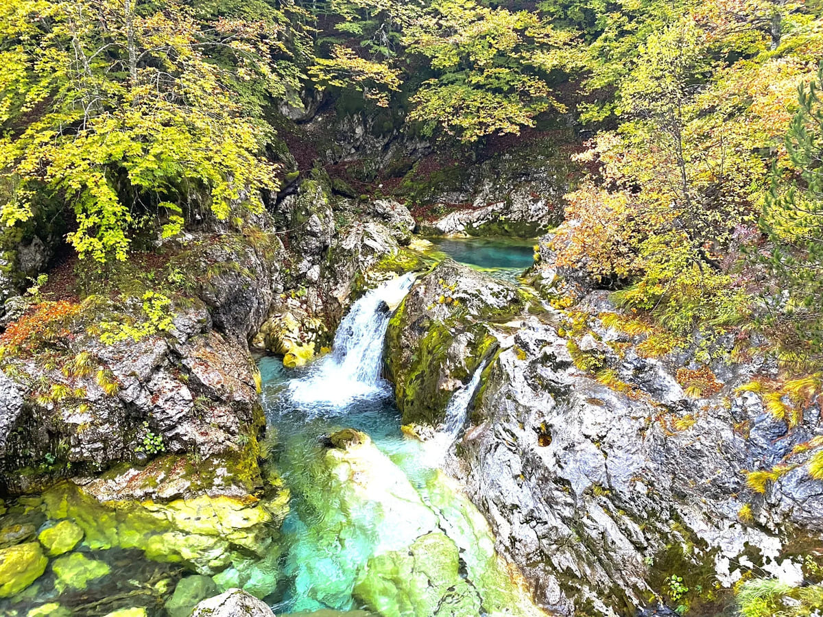
Kryezi Waterfalls Trail
📍 Fushë Arrëz, Shkodër, Albania | 🥾 Length: 2.4 km | 🕒 Est. 42m
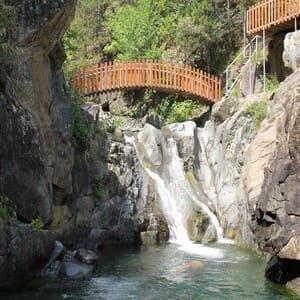
The Kryezi Waterfalls Trail offers a delightful escape into nature. Take your time, enjoy the views, and perhaps even take a refreshing dip in the crystal-clear waters. Remember to respect the environment and leave no trace behind.🌟
🗣️Trail Highlights:
- Ease of Hiking: The Kryezi Waterfalls Trail is generally considered an easy route suitable for hikers of all skill levels. Whether you’re a beginner or an experienced hiker, you’ll find this trail accessible.
- Scenic Beauty: As you follow the trail, you’ll encounter the mesmerizing Kryezi Waterfalls. These cascades add to the natural beauty of the area, making it a delightful hike. 🌄
- Trail Type: It’s an out-and-back trail, meaning you’ll retrace your steps to return to the starting point. 🔄
- Best Times to Visit: The ideal months for exploring this trail are May through September. During this period, the weather is pleasant, and the waterfalls are at their most captivating.
🗺️How to Get There:
- Begin your journey from Fushë Arrëz, a town in the Shkodër region of Albania.
- Look for signs or markers indicating the trailhead. The starting point should be well-marked.
“Short out-and-back to the Kryezi Waterfalls. Great swimming hole in beautiful Kryezi village.” 🏊♂️🌳
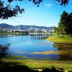
Liqeni i Tiranes (Artificial Lake of Tirana)
📍 Tiranë, Durrës, Albania | 🥾 Length: 5.6 km | 🕒 Est. 1h 15m
Liqeni i Tiranes, the Artificial Lake of Tirana, isn’t just a body of water; it’s an urban oasis inviting hikers to experience nature amidst the cityscape. The purpose of hiking around this picturesque lake is to blend the tranquility of nature with the vibrant energy of Tiranë, creating a unique adventure that resonates with both locals and visitors. 🚶♂️
🗣️Trail Highlights:
- Artificial Lake: Liqeni i Tiranes is a man-made lake located in the heart of Tirana.
- Purpose: It was created in 1955 by utilizing water sources from the area through voluntary efforts.
- Surroundings: The lake is surrounded by green spaces and offers a tranquil escape from the bustling city center.
- Activities: Visitors can relax, have fun, enjoy a meal, or explore the newly opened zoo nearby, which features a variety of animals.
🗺️How to Get There:
To reach Liqeni i Tiranes:
- Starting Point: Begin your journey from Tiranë, the capital city of Albania. For precise directions, you can use the Google App to navigate through the city.
- Public Transportation: You can take Bus L2 to get to Liqeni Artificial i Tiranes. The bus route will take you near the lake
Moderate Trails and Hikes in Albania
Kali Pjeter Trail
📍 Fushë Arrëz, Shkodër, Albania | 🥾 Length: 8.5 km | 🕒 Est. 2h 56m
This hidden gem in northern Albania offers more than just a hike—it’s like stepping into a fairy tale. The trail weaves through lush greenery, showcasing a vibrant mix of local flora that will make your heart skip a beat. As you stroll along, keep an eye out for signs of the rich cultural heritage embedded in the trail.
From traditional landmarks to hidden stories, the Kali Pjeter Trail is a treasure trove waiting to be explored. So, grab your comfiest shoes, take in that refreshing mountain air, and let the Kalipjeter Trail be your guide to an unforgettable outdoor experience! 🌳
🗣️Trail Highlights:
- Panoramic Views: As you ascend through dense forests and rocky terrain, be prepared for jaw-dropping panoramas. The trail offers sweeping vistas of the surrounding mountains, valleys, and the shimmering Lake Shkodër.
- Cultural Encounters: Along the way, encounter traditional Albanian villages where time seems to stand still. Friendly locals may invite you for a cup of strong coffee or share stories of their heritage.
- Flora and Fauna: The Kalipjeter Trail is a haven for nature enthusiasts. Keep an eye out for rare orchids, eagles soaring overhead, and perhaps even a glimpse of the elusive Balkan lynx.
- Historical Significance: Explore remnants of ancient settlements and shepherd trails that have connected communities for centuries. Imagine the footsteps of shepherds and traders who once traversed these same paths.
🗺️How to Get There:
- Starting Point: Begin your journey in the charming touristic village of Kryezi.
- Trailhead Access: The trailhead is easily accessible from the main road. Look for clear markers indicating the start of the trail.
Cape of Stillo
📍 Parku Kombëtar i Butrintit | 🥾 Length: 9.7 km | 🕒 Est. 2h 53m
Nestled within the untouched beauty of Butrint National Park, the Cape of Stillo Trail beckons adventurers seeking a blend of rugged landscapes, cultural intrigue, and breathtaking views. Lace up your hiking boots and prepare for an unforgettable journey. 🌟
🏛️ Cultural Places:
- Butrint Archaeological Site: Before or after your hike, explore the nearby Butrint Archaeological Site, a UNESCO World Heritage site with ancient ruins.
- Lëkurësi Castle: If time permits, visit Lëkurësi Castle in Sarandë, offering historical charm and stunning views of the city and sea. 🏰
🗣️Trail Highlights:
- Untamed Wilderness: This trail is not for the faint-hearted. It winds through an area rarely defined by trails, offering an authentic experience of Albania’s natural beauty. Expect twists through forests and dry land, with occasional river crossings.
- River Crossing: At the trailhead, you’ll encounter a river that must be crossed before embarking on your hike. The initial challenge sets the tone for the adventure ahead. 🌊
- Scenic Variety: As you trek, you’ll pass an old communist-era pool, groves of oak trees, and thickets of thorny plants. Keep your eyes peeled for glimpses of wild bulls, cows, fish, and various bird species. 📸
- Rewarding Views: The trail culminates in a breathtaking vista overlooking the Island of Tongo. If you’re feeling adventurous, consider exploring the neighboring fjords, where pristine beaches await—untouched by the usual tourist crowds. 🌺
🗺️How to Get There:
- Starting Point: Begin your journey in the city of Sarandë. 🏙️
- Travel Route: Head southeast on Rruga Mitat Hoxha.
- Continue On: Follow the road until you reach SH81.
- Destination: Your ultimate goal is to arrive at the entrance of Parku Kombëtar i Butrintit.
Practical Tips:
- Gear Up: Wear sturdy hiking pants and comfortable shoes, as thorns are common along the trail.
- Parking: Park on the other side of the river near the trailhead. 🚗
- Local Cafés: Visit cafés in nearby villages like Vrine, Shendelli, and Xarre.
- Wildlife: Keep an eye out for foxes and other small creatures.
Taraboshi MTB
📍 Shkodër, Shkodër, Albania | 🥾 Length: 7.4 km | 🕒 Est. 2h 50m
This trail is a hidden gem, providing breathtaking views of two lakes, three rivers, and even a cityscape. 🏙️ As you pedal or walk along the gravel road, the scenery unfolds, showcasing the natural beauty of the region. The best part? You’re likely to have the trail mostly to yourself, allowing for a peaceful exploration of the stunning surroundings. 🌳
Upon reaching the summit, a delightful surprise awaits – the option to follow a trail leading to Tarabosh, where antennas stand tall. 📡 From this vantage point, gaze upon the Adriatic Sea, and if the weather permits, catch a glimpse of Italy in the distance. The trail to Tarabosh is a wide path, making it accessible and enjoyable for hikers and bikers alike. 🚶♂️🌄
What adds a unique touch to this adventure is the presence of farmers living in the mountains. As you ascend, you might catch glimpses of their lifestyle, adding a cultural element to your journey. 🚜🏞️
In summary, this trail near Shkodër promises a delightful blend of natural beauty, panoramic views, and a touch of local culture. Whether you’re biking or hiking, the trail caters to both adventure seekers and those seeking a more leisurely exploration of the Albanian landscape.
🗺️How to Get There:
- Starting Point: Commence your journey from Shkodër, Shkodër.
- Route to Trailhead: Head northwest on the main road until you reach the trailhead.
- Trail Type: The trail is a gravel road, perfect for biking or hiking. 🚵♂️
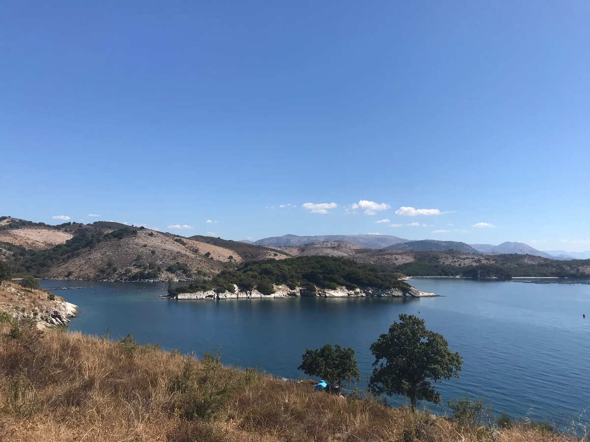
Lake Prespa Loop
📍 Pustec, Korçë, Albania | 🥾 Length: 10.6 km | 🕒 Est. 3h 11m
Embark on this trail, perfect for hiking and strolling, offering a sweet escape into nature’s embrace. 🚶♀️ Feel the solitude, as it’s a less-trodden path, letting nature lovers connect deeply with their surroundings, away from the bustling crowds.
The Lake Prespa Loop, a playground for the adventurous spirit! 🌪️ Unmarked paths add a dash of unpredictability, turning the journey into a thrilling quest for spontaneity and joyous discoveries.
Primarily winding through forests and mountains, the trail surprises with intermittent peeks at the breathtaking Lake Prespa. 🌅 Each step becomes a revelation, and hidden corners beckon photographers to capture the elusive beauty, crafting a visual tale of unexpected wonders.
Navigating the unknown is part of the Lake Prespa Loop’s charm. 💪 Despite challenges on alternative routes, adventurous souls find every obstacle a stepping stone for exploration.
🗺️How to Get There:
- Starting Point: Begin your journey in the town of Pustec, Korçë.
- The trailhead for the Lake Prespa Loop is located near Pustec.
- You can find the trailhead by following local road signs or using Google maps, head: Kallamas – PUSTEC, Albania
Drisht-Vilzë-Rragam MTB
📍 Tak Shkodër, Shkodër, Albania | 🥾 Length: 15.4 km | 🕒 Est. 5h 30m
Exploring the trail near Shkodër, Shkodër promises an exhilarating experience for mountain biking enthusiasts. Here’s what you can expect:
- 🏞️ Scenic Surroundings: Immerse yourself in the natural beauty of Shkodër’s surroundings as you navigate the trail. Enjoy picturesque landscapes and the tranquility of the area.
- 🚵♂️ Moderate Challenge: This trail is tailored for those seeking a moderately challenging mountain biking experience. Be prepared for varied terrain, providing just the right balance of excitement and adventure.
- 🌲 Secluded Pathways: Revel in the serenity of the trail, as it’s not heavily frequented. You’ll likely have the opportunity to enjoy the ride without encountering many other people, fostering a more intimate connection with nature.
- 🗺️ Trail Features: Anticipate diverse features along the route, ensuring that your mountain biking journey remains dynamic and engaging. From winding paths to subtle elevation changes, the trail caters to the adventurous spirit.
- 🌅 Limited Crowds: Experience the joy of exploration without the hustle and bustle of crowds. The trail’s less-traveled nature allows you to appreciate the solitude and beauty of the surroundings.
🗺️How to Get There:
- Depart from Shkodër: Start your exciting journey in Shkodër, Albania. 🚗
- Head North on SH1: Travel north on the SH1 road from Shkodër.
- Continue Toward Drisht: Follow the signs and continue on SH1 toward the town of Drisht. 🏞️
- Pass Through Drisht: Drive through Drisht, staying on the main road. 🏘️
- Continue on SH1: Keep following SH1 as it leads you further northeast. 🛣️
- Arrive in Rragam: Continue on SH1 until you reach Rragam, your destination, and the starting point of the mountain biking trail. 📍
Ensure you use a reliable navigation tool or map to assist you during the journey. Safe travels and enjoy your mountain biking adventure in Rragam! 🚴♂️🏞️
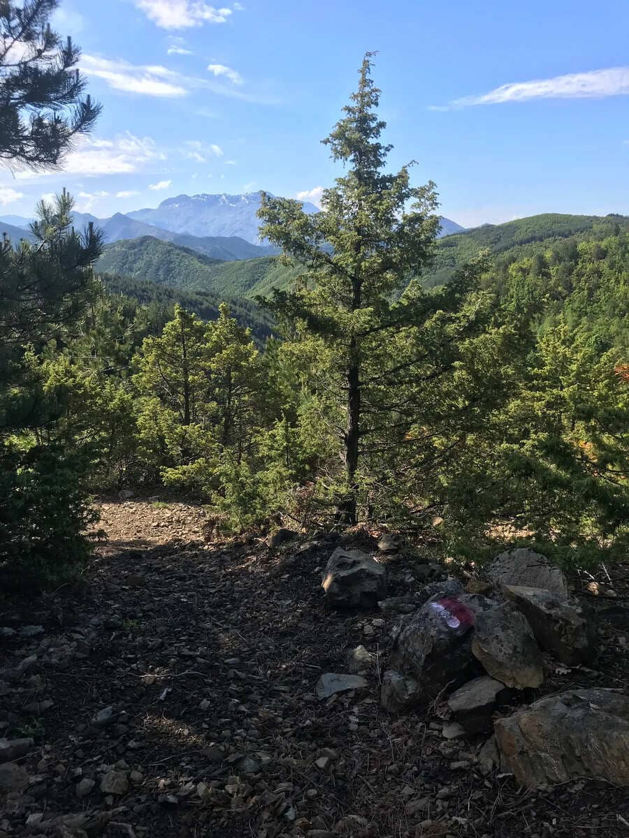
Llogara: Maja Thanasit
📍 Llogara National Park | 🥾 Length: 7.4 km | 🕒 Est. 2h 30m
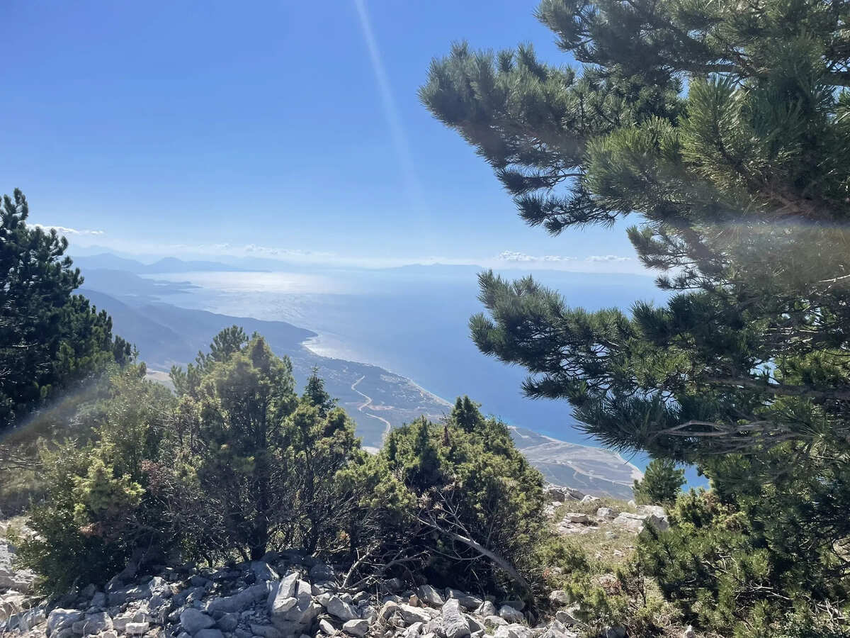
Nestled within the enchanting confines of Llogara National Park, the Llogara: Maja Thanasit trail unfolds as a hiker’s haven. 🏞️ The trail winds gracefully, guiding you through a diverse landscape that ranges from lush forests to panoramic mountain views.
As you venture along the path, the majestic Maja Thanasit captivates with its grandeur. 🏔️ The surroundings are adorned with vibrant flora, creating a tapestry of colors that changes with the seasons. Breathe in the crisp mountain air, and let the melody of rustling leaves and bird songs accompany your footsteps.
🗺️How to Get There:
- Starting Point: Identify your starting location (e.g., Shkodër, Vlorë, or any other city/town). 🚗
- Route to Llogara National Park: Navigate towards the Llogara National Park, using main roads like the SH8 or any other route that leads to the park.
- Reach Llogara Pass: Continue until you reach the famous Llogara Pass. The trailhead for Llogara: Maja Thanasit may start near this pass. 🏞️
- Trailhead Location: Look for signs indicating the trailhead for Llogara: Maja Thanasit within Llogara National Park.
- Parking and Facilities: Identify suitable parking areas and facilities for hikers, ensuring a convenient starting point for your trek.
- Begin the Hike: Strap on your hiking gear and start the trek along the Llogara: Maja Thanasit trail. 🥾
Hard Trails and Hikes in Albania
Curraj i Epërm – Lumi e Plans
📍 Tropojë, Kukës, Albania | 🥾 Length: 4.3 km | 🕒 Est. 1h 30m
Curraj i Epërm, with its spellbinding allure, is situated in the northern part of Albania. 🗺️ Picture yourself in the rugged beauty of the northern landscapes, where this hidden gem awaits your exploration. 🏞️
Tucked away in the Albanian outskirts, Curraj i Epërm graces the map with its pristine trails along the Lumi e Plans. 🚶♀️🌲 To reach this haven, you’ll navigate through the captivating scenery of the northern regions, where nature’s untouched wonders unfold at every turn.
🗺️How to Get There:
- Start in Tirana: Begin your journey in the lively capital of Albania, Tirana. From there, set your compass north, and hit the road with excitement bubbling in your veins. 🌆
- Navigate towards Shkodra: Head towards the charming city of Shkodra, where history and culture intertwine. Enjoy the scenic drive as you approach the northern wonders that await you. 🏰➡️
- Continue to Bajram Curri: The adventure doesn’t stop! Push onward to Bajram Curri, a town surrounded by majestic mountains. Let the anticipation build as you inch closer to your destination. 🛣️
- Final Leg to Curraj i Epërm: From Bajram Curri, follow the signs that lead you to the final stretch. The road may get a bit winding, but trust me, the destination is worth every twist and turn. 🔄🚗
- Hiking Bliss Awaits: Once you’ve reached Curraj i Epërm, park your vehicle and lace up those hiking boots. The trails along Lumi e Plans eagerly await your footsteps! 🥾🌿
Still pondering over what to wear 🤔🤔? Get ready for your Albanian adventure! Click the button below to explore our Ultimate Packing List. Unwind and discover more about gearing up for an exciting journey! 🌍🎒✨
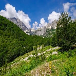
Final Thoughts: Trails and Hikes in Albania
In Albania, there are lots of beautiful places to walk and explore. You can go up high in the mountains 🏔️, or you can walk by the sea. There are trails with big views and trails with hidden waterfalls. When you walk, you might see animals like deer 🦌 or pretty flowers.
But it’s not just about the nature. In Albania, there are old castles 🏰 and villages in the mountains where people live. You can try Albanian food 🍽️ and maybe even join in on a dance at a local festival 💃. The people in Albania are friendly and like to share their stories with visitors. So whether you’re a pro hiker or just like taking a leisurely walk, Albania has something for everyone to enjoy! ✨